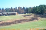
On Sunday, August 25, 2002, we took a drive along US Highway 16 into Keystone, then out on South Dakota Highway 40 to view the damaged caused by the Battle Creek Fire. It was not yet out, but was contained. There were travel restrictions still in effect for US Hwy 16 – 40 MPH limit, no parking, and left lane only most of the way.

Firefighers’ Camp – Home away from home

Camp Support

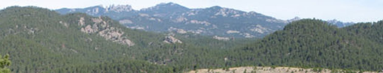
Mountain in the distance is severely burned

Burned areas right up to the west side of US Hwy 16

A lot of completely burned trees on this hill

More burned areas along US Hwy 16

Mt. Rushmore exit – 2 miles

The fire crossed SD Hwy 40

Burned areas on the south side of SD Hwy 40 with Mt. Rushmore in the distance

Fire was close to this buildings

Burned areas on both side of the road and on the distant hill

Only one of many `Thank You Firefighters’ signs

House destroyed but garage remains

Same destroyed house with melted dish. Garage and propane tank in tack

The fire burned right up to Rushmore Cave

Another angle of Rushmore Cave

No Parking along US Hwy 16

Speed limit 40 MPH on US Hwy 16

Burned area on east side of US Hwy 16

Hillside completely burned

nother burned hill on the west side of US Hwy 16

More Camp
To see some of the damage done by the Battle Creek fire, see the After Photos.
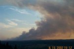
Photos take the evening of August 19, 2002

From South Canyon Country Estates – the fire is growing fast.

From the baseball (Post 22 & 320) fields’ parking lot south of Camp Rapid.

From Dinosaur Park hill.

Further up Dinosaur Park hill.

One of the Slurry Bombers.

Near Catron Blvd.

Slurry Bomber returning to airport.

Smoky Sunset in South Canyon Country Estates.

The wind appears to be shifting again.
Comparison Photos – Click to see larger versions
At approximately 10:30 AM MT on Monday August 19, 2002, the smoke has moved in. The pictures were taken almost a year apart.

This photo shows the smoke we have from the fire.

This photo was taken last year the day after we moved in.
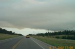
Photos taken Saturday, August 17, 2002 – Click to see larger versions
Here are some pictures we took Saturday afternoon.

From South Canyon Country Estates

I-90 near Exit 48

I-90 Exit 40. All the clouds and haze is from the fire.

SD Hwy 79 near St. Martin’s Monastery
Updates | Links | KOTA Articles | KNBN Articles | Maps
Photos
Updates
- July 25, 2009 – Update to remove dead links
- November 11, 2002 – Updated to remove dead links.
- August 30, 2002 9:55 PM MT – The total cost is over $7 million. Some additional KOTA news articles and photos have been added.
- August 29, 2002 6:00 PM MT – The fire officially controlled. Controlled means that 200 feet within the fire perimeter has been mopped up. There are still parts smoldering, and probably will until winter.
- August 27, 2002 8:36 PM MT – Added another link for KNBN.
- August 26, 2002 6:00 PM MT – Added some more links from KOTA.
- August 25, 2002 10:00 PM MT – Check out the after photos taken along US Highway 16 and SD Highway 40 on Sunday, August 25. The official size of the fire is reported as 13,700 acres with a to date cost of over $6.1 million. Control continues to be estimated for Thursday, August 29, 2002.
- August 24, 2002 9:45 PM MT – Battle Creek Fire Contained. The last official size as of 8:00 AM 8/24/2002 was 13,200 acres with a to date cost of over $5.2 million. Estimated control is still Thursday August 29, 2002 at 6:00 PM. There are still some road closures. Added articles from KOTA and KNBN.
- August 23, 2002 10:30 PM MT – New story by KNBN.
- August 23, 2002 10:30 AM MT – The estimated size is 13,000 acres and 75% contained. Estimated containment is 8/24/2002 6:00 PM MT. Estimated control is 8/29/2002 6:00 PM. Total cost so far is $4,000,000. Additional articles from KOTA added.
- August 22, 2002 10:25 PM MT – Closure order issued, added map, more photos on photo page.
- August 22, 2002 12:45 PM MT – Summary: 11,500 acres, 65% contained, 8/24 6:00 PM estimated full containment, 8/29 6:00 PM estimated control date, 1,250 personnel. All photos have been moved to the Battle Creek Photos page.
- August 22, 2002 7:30 AM MT – The estimated size is 11,500 acres and over 1,300 fire fighters are still working the fire. No new road openings. The fire did not receive much rain even though many parts of the Black Hills did get some significant rain.
- August 21, 2002 6:00 PM MT – Good progress on the fire. New stories from KOTA and KNBN.
- August 21, 2002 3:00 PM MT – More roads open, winds from the north and rain.
- August 20, 2002 7:45 AM MT – No changes yet to report concerning the fire. However, I did add links to the top of the page to get to various parts of this page easier.
- August 20, 2002 8:05 PM MT – They are estimating the size of the fire at 11,000 acres. We are getting a little rain and the wind is suppose to switch from the north overnight – good for us anyway.
- August 20, 2002 3:15 PM MT – There are currently 1,100 people and 150 fire engines fighting the fire. They anticipate up 1,600 fire fighters at the peak. If weather cooperates, they may contain the fire by this Saturday.
- August 20, 2002 12:25 PM MT – The estimated size is approximately 10,000 acres with over 900 personnel fighting the fire.
- August 20, 2002 8:15 AM MT – Updated fire perimeter map on bottom of page.
- August 20, 2002 7:45 AM MT – Official size of the fire is unknown, but is being reported as over 10,000 acres. Sheridan Lake Road is closed from the Victoria Lake Road turnoff east of Rapid City to Sheridan Lake/385.
- August 19, 2002 9:30 PM MT – The latest reports are the fire has grown to over 11,000 acres. No GPS flight is planned for tonight so no accurate size will be know. Evacuations have extended from Rockerville to Sheridan Lake Rd, to US Hwy 385 to US Hwy 16. Added photos link.
- August 19, 2002 6:00 PM MT – The fire has jumped US Hwy 16. It is now closed from Catron Blvd to the Keystone turn off. Evacuations are in progress from Sheridan Lake to the SE.
- August 19, 2002 4:34 PM MT – US Hwy 16 is closed between Rockerville and the Keystone exit. It is anticipated the fire will cross US Hwy 16 by 5:30 PM today.
- August 19, 2002 11:40 AM MT – The smoke has moved in. Below are two photos to see the difference. The new estimated size is now 7,851 acres, or about 12 square miles.
- August 19, 2002 10:05 AM MT – The Battle Creek fire is now the nations #1 fire fighting priority. It exceeds 7,000 acres.
- August 18, 2002 9:55 PM MT – The latest report from the Battle Creek Fire Incident Information page is the fire is at 6,581 acres and 20% contained with 817 assigned personnel and the cost exceeding $1.2 million.
- August 18, 2002 5:15 PM MT – The wind has switched directions. According to the Battle Creek Fire Incident Information page, Keystone will likely be evacuated and Mt. Rushmore National Memorial is also threatened.
- August 18, 2002 9:45 AM MT – The fire has now grown to over 6,000 acres.
- August 17, 2002 9:00 PM MT – A fire that started near the Black Hills Children Home grew quickly to over 2,500 acres due to very high winds with gust exceeding 60 mph.
Links with information and photos about the fire.
- Battle Creek Fire Incident Information – Information about the Battle Creek fire maintained by the U.S. Forest Service. (no longer available)
- South Dakota DENR – Alerts, Advisories, and Health Effects from Smoke
- Battle Creek Wildfire Visitor Advisory
- KOTA – Provides updates on a regular basis.
- Battle Creek Fire Contained 8/30/2002 1:27:12 PM
- Battle Creek fire rehabilitation work going to the dogs 8/29/2002 7:25:30 PM
- No word on cause of Battle Creek Fire 8/26/2002 5:14:47 PM
- Battle Creek fire update 8/26/2002 11:24:13 AM
- Battle Creek Fire Contained 8/24/2002 8:59:35 PM
- Crews not out of the woods, but fire is winding down 8/23/2002 2:34:19 PM
- Travel restrictions in National Forest 8/23/2002 9:33:30 AM
- Another road opening — residents only 8/23/2002 9:27:02 AM
- Cleared areas helped save homes in fire 8/23/2002 8:35:08 AM
- More road openings announced; 74 percent containment 8/23/2002 7:59:18 AM
- Slurry is tough to clean up, but it’s a blessing, too 8/23/2002 7:48:53 AM
- Want to help? Firefighters could use some supplies 8/22/2002 3:49:54 PM
- Battle Creek Fire: Sheridan Lake Road open 8/22/2002 8:13:17 AM
- Battle Creek firefighting effort going well 8/21/2002 5:16:06 PM
- Highway 16, other roads re-open — with conditions 8/21/2002 1:06:35 PM
- Road closure update 8/21/2002 8:34:19 AM
- Battle Creek Fire: Some evacuees can go back home 8/21/2002 8:26:45 AM
- Four days into fighting fire, Forest Service faces the public 8/20/2002 8:52:07 PM
- Battle Creek fire evacuees wait, worry 8/20/2002 6:22:50 PM
- Calm weather, firefighters gain on the Battle Creek Fire 8/20/2002 6:18:10 PM
- Community meetings on the Battle Creek fire 8/20/2002 1:12:29 PM
- Fire managers briefing reporters 8/20/2002 1:10:22 PM
- Fire crews cautiously optimistic this morning 8/20/2002 11:41:58 AM
- Fire evacuations remain in effect 8/20/2002 7:44:40 AM
- Governor clarifies latest fire evacuation areas 8/19/2002 7:21:20 PM
- Rockerville, Sheridan Lake area evacuated 8/19/2002 6:25:35 PM
- Battle Creek Fire jumps Highway 16 8/19/2002 5:22:16 PM
- Highway 16 blocked from Catron Boulevard south; fire jumps Highway 16 8/19/2002 4:59:20 PM
- Part of Highway 16 closed 8/19/2002 4:06:06 PM
- Battle Creek Fire: More areas evacuated; one-lane traffic on Highway 16 8/19/2002 3:45:19 PM
- Battle Creek fire evacuation update 8/19/2002 1:08:41 PM
- Battle Creek fire update: wind shift expected today 8/19/2002 11:03:55 AM
- 4 evacuated areas now open 8/19/2002 9:55:09 AM
- Evacuations still in effect; Battle Creek is nation’s top fire fighting priority 8/19/2002 7:58:28 AM
- Fire evacuations still in effect 8/19/2002 7:58:28 AM
- Evacuations and Closures 8/18/2002 9:43:29 PM
- Fire Grows to 6,600 Acres 8/18/2002 9:33:49 PM
- Access to some homes restored 8/18/2002 4:25:34 PM
- Evacuation advisory expanded for Battle Creek Fire area 8/18/2002 1:36:32 PM
- Slurry bombers flying over Battle Creek fire 8/18/2002 12:19:43 PM
- Wind shifts cause more pre-evacuation notices in Battle Creek fire 8/18/2002 10:37:52 AM
- Battle Creek Fire burning two miles east of Keystone 8/18/2002 8:39:07 AM
- Battle Creek Fire Grows to 6000 Acres 8/17/2002 11:01:46 PM
- Rockerville Evacuated 8/17/2002 8:44:53 PM
- Battle Creek fire: new evacuations ordered 8/17/2002 2:48:28 PM
- Battle Creek fire update: aerial video shows two small areas burning, smoke blankets area 8/17/2002 1:46:02 PM
- Battle Creek fire update: more evacuations ordered 8/17/2002 11:38:55 AM
- Battle Creek fire explodes to 3,500 acres, the winds died down 8/17/2002 8:56:55 AM
- Battle Creek Fire Update Saturday Morning 8/17/2002 6:52:05 AM
- Road closures due to Battle Creek Fire 8/16/2002 11:37:48 PM
- Fire Rages Through Rockerville 8/16/2002 11:26:19 PM
- KNBN
- Power lines may have caused Battle Creek Fire Aug. 27 – Electric power lines may be the cause of the Battle Creek Fire that burned nearly 14,000 acres of Black Hills Forest Land last week.
- Battle Creek Fire 100% contained Aug. 25 – The Battle Creek Fire is now 100% contained and firefighters are confident they have won the battle with the fire that got uncomfortably close to Keystone.
- Battle Creek fire now 87% contained Aug. 24 – The Battle Creek fire has been burning for over a week and has grown to over 13,000 acres.
- Battle Creek firefighters start to head home Aug. 23 – With the Battle Creek Fire at such a high percentage of containment, fire officials have begun the process of sending some fire crews home.
- Recent rains help quell Battle Creek fire Aug. 22 – Rain overnight helped quell, but not completely extinguish, the Battle Creek fire, raging south of Rapid City since last Friday night.
- Mother Nature lends a hand to firefighters Aug. 21 – High humidity and light winds are helping firefighters south of Rapid City with the Battle Creek fire.
- Volunteer firefighters play a large part in combating wildfires Aug. 20 – Hundreds of fire fighters from across the country are in the Black Hills helping to contain and control the Battle Creek fire. But not all of those fire fighters are getting paid, or are even expected to be on the lines.
- Battle Creek fire meeting to be held in Rapid City Aug. 20 – Residents of the Black Hills affected by the Battle Creek Fire and evacuations caused by the flames and smoke are invited to a public information meeting Wednesday night.
- Fire closures and evacuated areas Aug. 20 – Here is a list of highway closures because of the fire.
- Firefighters make headway against Battle Creek Fire Aug. 20 – Firefighters battling the Battle Creek Fire in the central Black Hills got some help from calm winds overnight.
- Janklow expresses frustration over Forest Service fire response Aug. 19 – Governor Bill Janklow expressed his frustration Sunday at what he called the forest service’s slow response to the Battle Creek fire.
- National Guard troops assist with fire fighting efforts Aug. 19 – More than 800 personnel are assigned to the Battle Creek fire. A number of them are members of the South Dakota National Guard.
- Battle Creek fire causes closure of Highway 16 Aug. 19 – Highway 16 has been closed between Keystone and Sitting Bull Cave as the Battle Creek Fire approaches.
- Battle Creek Fire rages on Aug. 18 – The Battle Creek Fire is now estimated at 6,500 acres.
- Janklow expresses disapproval of fire management Aug. 18 – Both South Dakota Congressman John Thune and Governor Bill Janklow were at the fire Sunday observing the management, plan of attack, and the fire activity.
- Evacuees moved to South Dakota School of Mines Aug. 18 – The Black Hills Chapter of the American Red Cross has set up a shelter for evacuees of the Battle Creek Fire.
- Battle Creek fire update Sunday 12:00 Aug. 18 – The Battle Creek fire has grown to an estimated 6,277 acres.
- Battle Creek fire update Sunday 10:00 am Aug. 18 – Keystone area residents were put on alert Sunday morning that they may have to evacuate later today because of fire.
- Battle Creek fire becomes more dangerous Aug. 17 – The Battle Creek fire, which has been burning since Friday afternoon, is becoming more dangerous as afternoon and evening winds out of the south and southwest are pushing the fire toward residences around the Rockerville area.
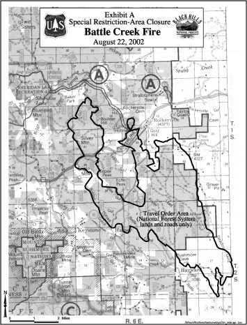
Map of the area
To give you an idea of where our house is located in reference to the Battle Creek fire, below is a map of the area. The red star to the left of Rapid City is where our house is located. The red area east of Keystone shows the approximate area of the fire as of Wednesday 8/21/2002. Our house is approximately 7 miles away. The small green area southwest and next to Keystone is Mt. Rushmore National Memorial. The large green area southwest of the fire is Custer State Park.

Battle Creek Fire Perimeter

Battle Creek Fire Area Closure
A site for myself, family, friends, and anyone else that wants to visit
You must be logged in to post a comment.