November 11, 2002 – Updated to remove dead links. The KOTA news titles remain but the links are all dead so have been deactivated.
July 20, 2000 10:00 PM MT – 673 acres and 70% contained. 100% containment estimated at 7/21/2002 6:00 PM.
July 19, 2002 8:00 AM MT – Using global position equipment, the size of the fire area was determined to be 600 acres.
July 18, 2002 11:45 PM MT – With cloud cover and higher humidity, the fire did not spread much today. Added some of our photos taken this evening.
July 18, 2002 12:30 PM MT – The fire is now estimated over 1,200 acres with no containment estimate.
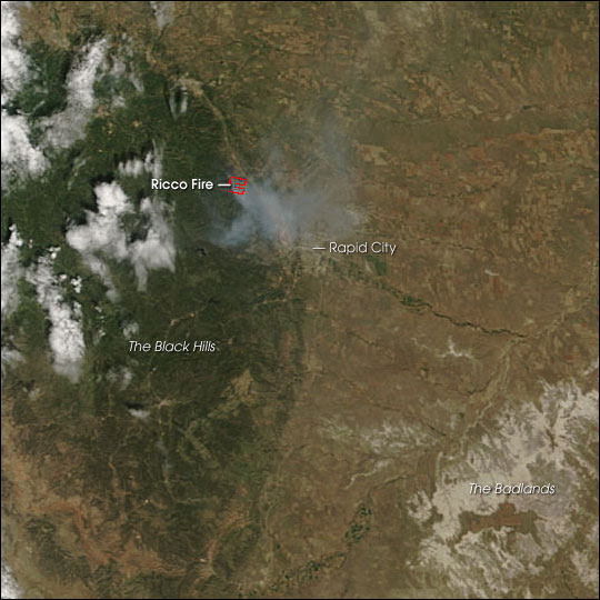
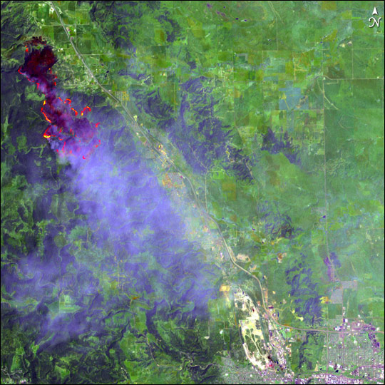
July 18, 2002 8:00 AM MT – 800 acres at 40 percent contained. This fire is burning near Piedmont. Crews are constructing fireline on the rim of Little Elk Canyon. One hundred residences in the Piedmont Meadows subdivision are threatened and have been evacuated.
July 17, 2002 11:55 PM MT – The fire grew to over 400 acres. It is estimated to be 40% contained. Major concern is the north end because the Mountain Pine Beetle infested Beaver Park area is located in that direction. Additional evacuation have occurred with more closures
July 16, 2002 11:00 PM MT – Fire started around 2:00 PM MT along I-90, burned grass and spread into trees. It is currently about 280 acres and is 50% contained. Thirty homes were evacuated in the area.
Thunderstorm fights fires, starts new ones 7/21/2002 10:19:53 AM
Noon update on fires in the Black Hills, 4,000-acre grassfire east of Sturgis 7/20/2002 12:15:44 PM
Update on Little Elk Fire 7/20/2002 8:48:28 AM
Thunderstorms spark new fires overnight 7/20/2002 8:45:16 AM
Little Elk Fire Update Friday night 7/19/2002 9:21:28 PM
Update on lightning-caused fires in Black Hills 7/19/2002 9:17:10 PM
Fire gets a name change 7/19/2002 5:40:09 PM
Little Elk Fire Update 7/19/2002 3:59:08 PM
More fires in the Northern Black Hills 7/19/2002 3:57:25 PM
Elk Creek Fire: the latest this evening 7/18/2002 6:00:40 PM
Little Elk Creek Fire Update: evacuation orders lifted in two places 7/18/2002 11:58:55 AM
Little Elk Creek Fire Update: 1,200 acres burned 7/18/2002 9:44:14 AM
Little Elk Creek Fire update Wednesday night 7/17/2002 10:00 PM MT
Little Elk Creek Fire Update: winds not helping 7/17/2002 12:01 PM MT
Firefighters continue to push on Little Elk Creek Fire 7/17/2002 9:01 AM MT
Little Elk Creek Fire Update 7/16/2002 9:15 PM MT
Little Elk Creek Fire Update 7/16/2002 7:48 PM MT
Piedmont area fire update 7/16/2002 5:47 PM MT
Fire Near Piedmont 7/16/2002 3:58 PM MT
Fire Photos – Click to see larger versions
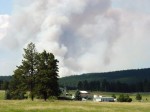
Here are some pictures we took while driving on I-90 Thursday evening. Over the past several days, many people were stopping along the interstate to talk pictures, which is illegal. Law Enforcement Officers were busy keeping the traffic flowing safely.
Fire Sunset
Homes near the Little Elk fir as seen from I-90
Grass fire becomes forest fire
If you click on the last photo to view the large version, you will see the grass before the hill and the hill is burnt.
Map of the area
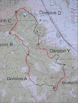
Little Elk Fire Perimeter Map
To give you an idea of where our house is located in reference to the Little Elk Creek fire, below is a map of the area. The red star to the left of Rapid City, on the lower center of the map, is where our house is located. In the center of the map is Piedmont. The red circle shows the approximate area that has burned as of Thursday 7/18/2002. Our house is located about 9 miles from the burned area. Little Elk Fire Location Map
Links with photos and more information about the fire.
Grizzly Gulch Fire map – Map provided by state showing affected area.
South Dakota Fire Update – This site is maintained by the state. It has the latest updates, maps, and photos.
X-Rock 101.1, 103.5 – This station provided live coverage the fire, taking call-ins, etc. Many people affected by the fire listened to this station. They were even told the fire officials listened to the station to keep track of the fire’s progress based on the information callers provided. You can listen to them over the internet from their web site.
KOTA – KOTA TV has been providing regular updates on the status of the fire.
Warner Images Photos – Tom Warner is a photographer and pilot. He has some interesting photos on his site.
Deadwood Digital Television – This site has several pages. Below are direct links to this sites various photo pages.
Fire in Deadwood
Sunday Morning
Support Crews
fast “phone” download..
The “Feds” are about to take over..
Returning home..
The “mop-up”
“day 1” from other angles..
Deadwood Fire – Photos on Blackhills.com
NOAA Fire Weather – This site provides weather forecasts for fire areas.
Most photos are samples of what can be found at the various links above. Thanks to State of South Dakota, dvdtv.com, blackhills.com, and warnerimages.com for providing photos on their sites. Fire photos from these sites are no longer available.
Updates
July 25, 2009 – Invalid links removed.
November 11, 2002 – Several links are no longer valid so have been removed. Other information has been copied down to preserve the information.
July 8, 2002 5:15 PM MT _ The fire was officially contained at 6:00 PM on Sunday July 7, 2002. I added warnerimages.com link and photo. This will probably be the last update to this page.
July 6, 2002 2:15 PM MT – The fire is standing at 10,700+ acres and is 85% contained. Added a couple of pictures I took.
July 4, 2002 5:00 PM MT – The fire now covers 10,000+ acres and is 50% contained. Added some more links, added some more sample photos, and cleaned up some other things.
July 3, 2002 11:30 PM MT – The fire now covers 9,800+ acres and is 50% contained. Found some more links and added some pictures.
July 3, 2002 12:30 PM MT – Some of the sites changed their links. For those sites with multiple pages, my links now just point to the main page. The latest reports are the fire is now over 9,000 acres.
July 1, 2002 8:10 PM MT – More links to more photos.
July 1, 2002 2:45 PM MT – Added link for NIFC.
July 1, 2002 5:55 AM MT – Add dwdtv.com page three link above.
June 30, 2002 9:30 PM MT – This page was created and the information from the home page was moved to this page.
June 30, 2002 6:00 PM MT – Another link to more pictures added.
June 30, 2002 12:10 PM MT – The Grizzly Gulch fire, also referred to as the Deadwood fire, which started on Saturday June 29 is only causing smoke for us. On Saturday evening, around 10:00 PM MT, the front moved through and changed the wind direction. It caused the smoke to blow towards us and it was very smoky in our area. If you looked out the window, it appeared like a heavy fog was in the area. On Sunday morning, around 8:00 AM MT, the smoke smell was still a little strong, but better than the night before. You could see smoke in the distance. By noon, with the wind changing directions, the smoke smell was gone.
Map of the area
To give you an idea of where our house is located in reference to the Grizzly Gulch fire, also referred to as the Deadwood fire, below is a map of the area. The red star to the left of Rapid City, on the lower right end of the map, is where our house is located. In the upper left end of the map is the Lead Deadwood area. The red arrow shows the approximate location of where the fire started. It headed NE and as it headed that direction, it spread wider, coming to Deadwood. When a front passed through around 10:00 PM MT, the wind switched to the NW, causing the fire to spread SE. The red circle shows the approximate area that has burned as of Sunday evening. The green circle shows the approximate location of the evacuation area. Our house is located about 22 miles from the burned area.
This image was originally found on the South Dakota Web Site.
A site for myself, family, friends, and anyone else that wants to visit






You must be logged in to post a comment.